Documenting the Documenters
This year, as part of our project, we are making an educational movie about penguins. Ian and Grant have been filming a lot of footage of Adélie and emperor penguins and Weddell seals and recording sounds using equipment generously loaned by Cornell's Macaulay Library of Natural Sounds.Here are some images of the documenters at work:
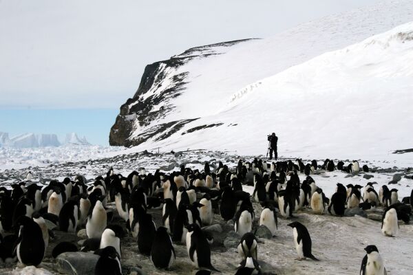
 Ian filming Adélie Penguins on Beaufort Island
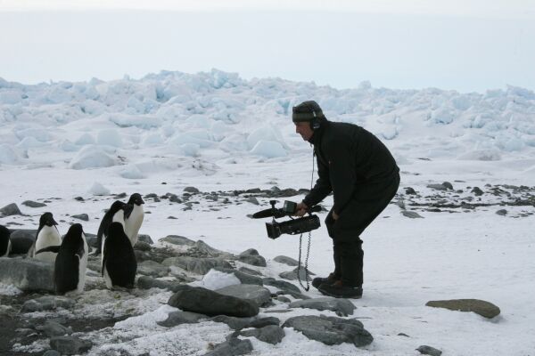
 Grant filming on Beaufort
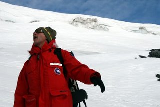
 Grant and Ian taking in a view of the frozen Ross SeaWe have also been fortunate to cross paths with filmmaker Werner Herzog. He and cinematographer Peter Zeitlinger and musician/producer/SCUBA diver Henry Kaiser are here on an NSF artists and writers grant working on a documentary about Antarctica, or Antarctic researchers, or both (didn't elaborate).When I first passed Herzog in the lab hallway at McMurdo I mistook him for a professor I vaguely know from Stanford University - my brain was trying to place him in the familiar realm. Thus I embarrassed myself right off the bat, though he seemed mildly flattered to be mistaken for a professor, and wanted to know what kind of research this professor does. He studies climate change; "ah, climate change! interesting subject" he said in his elegant Bavarian accent.Yesterday Herzog and Zeitlinger came to Cape Royds to film the penguins and interview David Ainley, our project leader. Herzog sat David down on a cliff overseeing the colony and asked challenging, interesting, and increasingly personal questions. It was fully unscripted. Two humans with famously difficult personalities faced each other on a cliff overlooking the frozen sea while one mostly listened and the other spoke of the feeling of one's smallness in the face of Antarctica's vastness, his (literally) dreams of overcoming the sea and becoming a seabird biologist, penguin social and anti-social behaviors, and the notion of morphing into a penguin. I'll leave the rest up to your imagination, or you can see for yourself if and when Herzog's Antarctic footage is released.I wish I had one of our video cameras so I could film Herzog filming us filming him ... that would have put an interesting twist in our penguin movie!
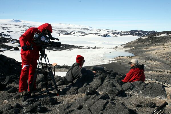
 Peter Zeitlinger (filming) and Werner Herzog (middle) interviewing David Ainley at Cape Royds
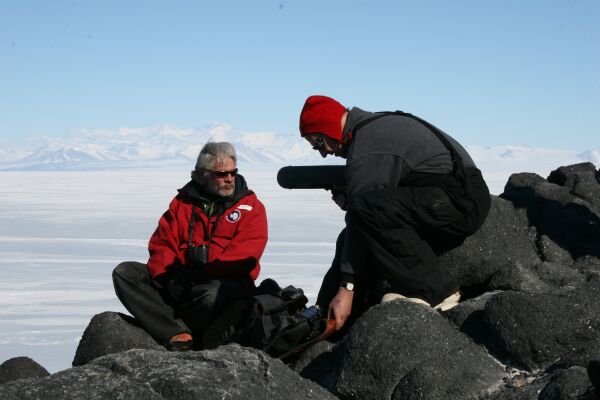
 David Ainley (left) and Werner Herzog with the Transantarctic Mountains in the background
Hut-bound
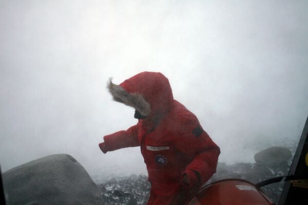
The storm lasted a total of three days. We had barely begun to search for banded birds and GLS tags down at the colony when the storm forced the four of us inside our tiny 2-person hut. What does one do when itching to be outside yet stuck in an orange box in the middle of Antarctica with the wind raging at 70-90 mph outside? Eat, read, eat some more, make tea. Be thankful for the four walls and roof that are still standing strong. I tried to learn R, sorted through my photos, read, and played with penguin data from last year's GLS tags.One night we tried to retrieve our sleeping bags from the tents so that we could sleep inside. The wind was so strong that I could barely make it past the corner of the hut (where the wind picks up speed) and up the 10 m to our Scott tent. I could lean into the wind but not move forward. I finally retreated to the lee of the hut and gave myself a running start, hit the wall of wind with enough momentum, and went headfirst into the oncoming blizzard. Returning to the hut with a flapping sleeping bag in my arms was equally challenging, but I clutched it with all my strength, braced my steps, and finally came around the corner of the hut totally out of control, slamming into Amélie who was about to open the door with all of her sleeping gear in her arms. We laughed and retreated into the comfort of our tiny space.My favorite thing to do when the wind is so strong is to stand outside and let it hold me up. My mind is still tempered by the relative mildness of the temperate climate I grew up in (the climate in northern Italy is pretty uneventful by comparison), so I am still blown away by the fact that any wind can be so strong as to hold someone up or, as the case may be, blow someone away. (Rumor has it that happened once at McMurdo. I don't know how strong the wind was, but the person stepped outside and was never seen again.) This wind was definitely not strong enough for the latter, so Grant and I stood on the snow and played with how far we could lean before falling. I attained a near 45 degree angle several times before gravity took over. Even better is to lay flat on the ground, where the wind is blowing above you but not so low to the ground, and watch the snow blowing and the clouds swirling overhead from your layer of relative calm.Our internet, of course, is dead. The WiFi repeater on top of Mt. Terror is probably covered with ice, so we have to wait for the comms shop people to fly up there to fix it, which will probably take at least a week. On November 23, two days after the storm ended, I flew to Cape Royds, the smallest Adélie colony on the western side of Ross Island, where I am spending 5 or 6 days working with David, and the internet here works great.Some more photos from the storm: Grant tying down the wireless dish during a lull in the storm
 Amélie coming back to the hut (photo by Grant)
 Streaky clouds that form at high altitude during high winds. Our wind turbine, which compensated for the lack of solar energy and kept the hut fully powered during the storm, is in the foreground.
Back to Crozier, First Storm
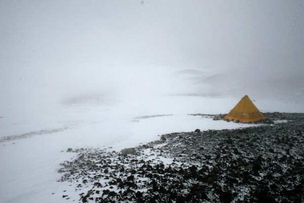
We're finally at Cape Crozier, and this is what the view out of our hut window currently looks like: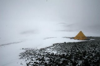 Cape Crozier white-outI stepped out very briefly and was immediately inundated with snowdrift swirling around me at 50 miles per hour. My camera lens was instantly coated with ice, so I quickly retreated into the heated comfort of our 30 year old hut. This hut has withstood many serious storms, especially during the dark Antarctic winter, but sometimes I wonder how many more it will last through. After particularly stormy winters we find large pebbles and small rocks lodged into the side of the hut, and the external orange paint on the windward side is almost all gone from getting pummeled with wind-borne debris since 1974. Luckily the foundation is deeply frozen into the permafrost, so our chances during this relatively mild storm are quite good.
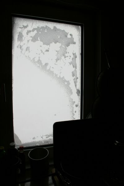
 Crozier hut windowThis is a view of the actual window, encrusted with snow. On clear days this window has the most spectacular view I have ever seen - the glacier flowing down to the sea with its rocky lateral moraines, grounded tabular icebergs along the shore, a vast expanse of sea ice and bergy bits, and Beaufort Island asleep in the middle of the Ross Sea. Snow, rock, sea, and ice. Occasionally seals sleeping on the fast ice, tiny penguin dots hurrying toward the ice edge, and if we are lucky some minke whales and orcas.Oops, our wireless link to McMurdo station just died - the antenna either blew away or is totally covered with ice, so I'll have to use the satellite phone to finish posting this, which is too slow for photos. It may be a few days before we have internet connectivity again and before I can post more photos. It's amazing to be here again in this Crozier universe - so removed from the mundanities of the "other" life. I love looking out the window and seeing ... well, nothing at the moment. Off to a sip of Scotch, maybe a cookie, and then to brave the fierce winds for 10 meters to the tent and the cocoon of our sleeping bags.
Journey to Beaufort
Beaufort scale 1. a scale of wind forces, described by name and range of velocity... 2. a scale of the states of sea created by winds of these various forces... [1855–60; named after Sir Francis Beaufort (1774–1857)]" --Random House Unabridged DictionaryLast Thursday we flew to Beaufort Island, which lies about 100 km to the north of McMurdo station. We needed to search for banded penguins and had to go while we could still fly there - the sea ice around Beaufort is rapidly thinning and, since our helicopters cannot fly over open water, we had to take the opportunity while we could.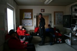 Katie, Dave, Ian, and Grant waiting at the helo (helicopter) hangar
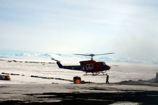 A helo tech attaching a sling load to another helicopter (note the Royal Society Range along the horizon)
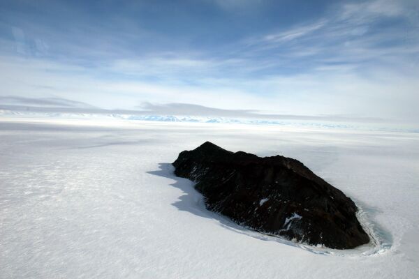
 Inaccessible Island frozen in the fast ice (ice that is attached to the shore)
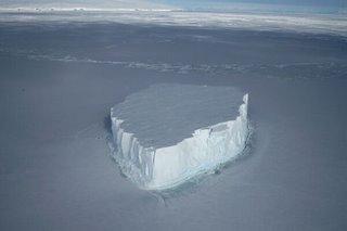 A lone tabular iceberg frozen in space
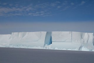 The geometry of an icebergIcebergs are incredibly evocative in their myriad shapes and hues of white and blue.
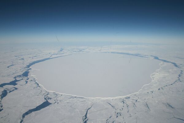
 The ice cap over Mt. BirdThe "claw" marks are heavily crevassed areas that form over bumps and knolls in the underlying rock as the sheet of ice flows over them. Some of those crevasses are large enough to swallow a helicopter or two.
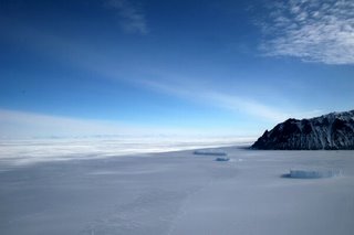 Approaching Beaufort Island, still surrounded by iceThe tabular icebergs have been frozen in place since last year. This will all be open water by mid-December. We'll get to stare at Beaufort Island from Cape Crozier for the next 2.5 months, but we may not have another opportunity to fly there.
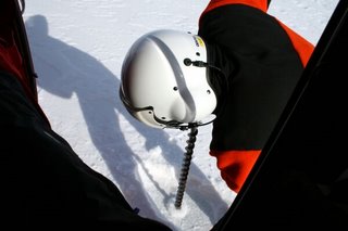 Mark testing the ice thicknessWe landed briefly a few hundred meters from the island to test the ice thickness. Mark, the helo tech, drilled a hole in the ice while the pilot kept the helicopter running - after 24 inches water gushed out of the drill hole. The ice was too thin for us to land safely (we needed at least 30 inches), so we moved on.
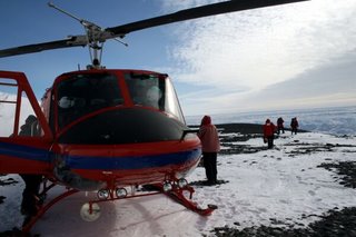 Over ancient bonesWe couldn't find a place with ice thick enough to land near the main colony so we ended up on the other side of Beaufort Island, where there is a second, very small Adelie Penguin colony. We landed on a wide, rocky terrace that used to be occupied by Adelie Penguins up until about 30,000 years ago; its entire surface is covered with penguin bones. Our friend and colleague Steve Emslie, who studies fossil penguins, dated this colony by digging through the ancient guano and using the penguin remains that still abound.
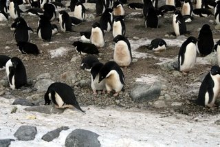 Living penguins!Our first penguins this season, yay! The front pair were flirting heavily and, in proper Adelie territorial manner, staring down all passers-by, such as the poor lone penguin collecting pebbles at the edge of the snow. They are probably going to lay eggs any day.
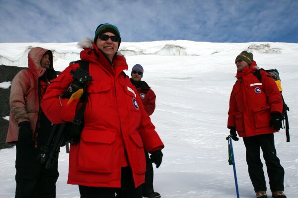
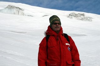 David Ainley, our fearless leader.
 Dave again, looking a little less fearless...
 Katie Dugger, fearless statistician and fellow penguinologist, with Barry (the pilot), Mark, and David.
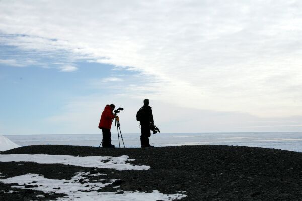
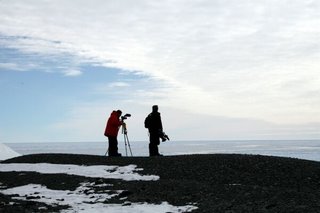 Grant and Ian taking in a view of the ice-covered Ross Sea.
B15 is gone
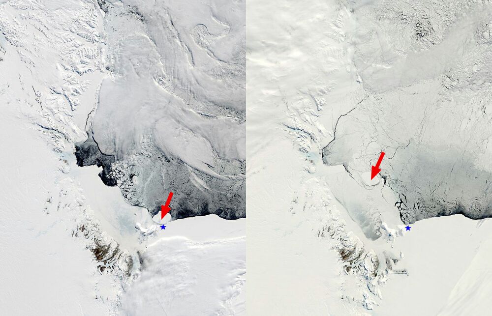
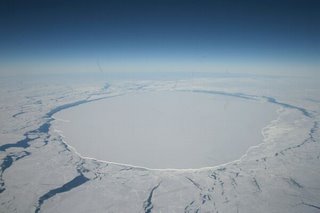 B15-J from the airThe other day when we were flying in we passed right over B15-J, the last remnant of the mega iceberg that has been blocking the three Adelie Penguin colonies on Ross Island for the last 4 years. This piece was grounded in front of Cape Crozier until a few months ago, when it finally broke loose and floated north. It has been causing all kinds of problems for the penguins because it blocked access both to the breeding colonies and to the foraging areas, so we're very excited to see how the penguins do this year without the iceberg blocking their way.
 B15-J (red arrow) grounded in front of Cape Crozier (blue star) in November 2005 (left) and 200 km away in November 2006 (right).
White again
We're back in Antarctica! This will be my 5th season and Grant's 11th. Our group this year consists of 10 people. Seven of us (David Ainley, Kate Dugger, Grant, myself, Ian Gaffney, Amelie Lescroel, and Valere Marsaudon) just arrived together, while three more (Jean Pennycook, Lloyd Fales and William Sladen) are coming in December and January. In addition to the usual penguin research, this year we're also filming an educational DVD about the project, which Lloyd Fales is directing and producing. Ian and Grant will be filming a lot of the footage over the next couple of months.We arrived at McMurdo station on November 7th and are scheduled to fly to our field camps on November 15th, weather permitting. We're going through the usual debriefing, sorting, packing and making sure that we have enough supplies for the next two and half months in the field. It's an exciting and stressful time - amazing to be back in this breathtaking place, overwhelmed with all the work that lays ahead, and excited at the prospect of spending the next 10 weeks at Cape Crozier.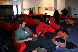 USAP terminalGrant waiting at the US Antarctic Program's terminal in Christchurch, New Zealand. The red parkas strewn across the chairs are part of the ECW (Extreme Cold Weather) clothing provided by the program.
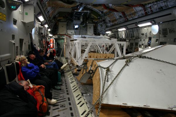
 Inside the C-17The c-17 is a military cargo plane that flies people and cargo to and from Antarctica. Our flight was loaded with telescope parts (big white structures) bound for the South Pole. The flight from Christchurch to McMurdo lasts about 5 hours, with an additional 3 hours for those going to the South Pole.
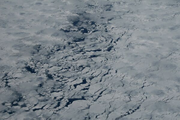
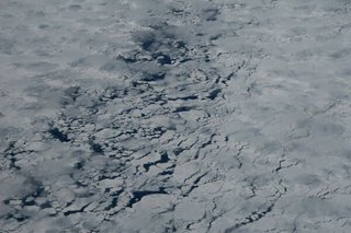 Sea iceThe C-17 has very few windows - two near the front and two near the back - so for most of the flight I was unable to see what lay below. As we neared Antarctica I became quite restless and frequently wandered up front to check for the first signs of a frozen landscape. This is a glimpse of pack ice through the low clouds. We flew over hundreds of miles of ice-covered ocean before seeing any terra firma.
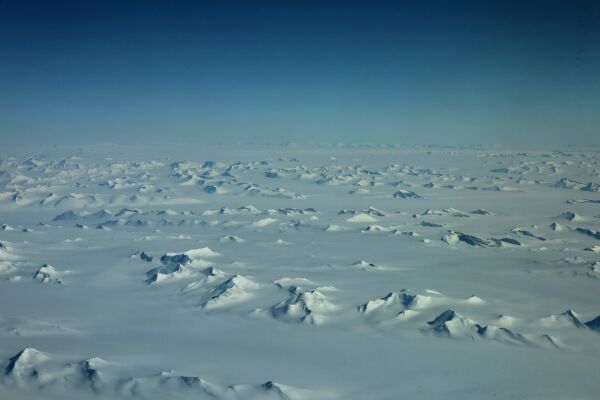
 Antarctic mountainsI invited myself into the cockpit to take in the stunning landscape - sea ice giving way to rugged, rocky coastline to glaciers flowing into the sea to endless mountains blanketed in snow and ice...
 Sea ice runwayApproaching McMurdo, which is a research station of about 1200 people tucked into the small bay beneath the last hill (Observation Hill) in the center/background. The flat white in the foreground is all frozen sea, with the sea ice runway in the foreground. The C-17 lands on about 1.5 meters of ice, thick enough to absorb the impact of a landing cargo plane without cracking and sending us into the frozen depths of McMurdo Sound. By December the sea ice runway turns into slush or open water, so the airport has to be moved further south onto the Ross Ice Shelf, which lays between Observation Hill and White Island (left background) and stretches hundreds of miles to the south. The ice shelf is about a hundred meters thick and is strewn with crevasses and giant "rollers" of flowing ice in some areas.
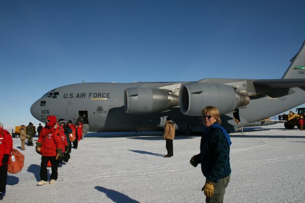
 Getting off the plane