Transantarctic Mountains
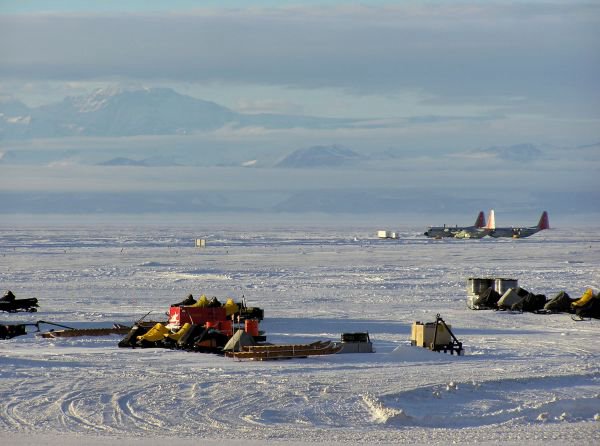
 Last night I left our lab at 1 in the morning. The sun was hanging low to the south and the light was filled with violet-blue-orange hues. A recent storm had left thin strands of clouds and snowdrift along the horizon, and the mountains to the west looked very striking covered in flowing glaciers and slanted sunlight, so I decided to walk out onto the sea ice just outside of town. The frozen surface of McMurdo sound strecthes westward for dozens of miles before running into the Victoria Land coast, where the Transantarctic Mountains rise directly out of the ocean and stretch all across the Antarctic continent. The flat sea ice and ring of mountains reminded me very much of Nevada's Black Rock Desert, where dry, bone-white playa lake beds gleam in the desert sun, circled by reddish peaks and streaked by passing sand storms and the occasional dust devil. Right in the middle of both of these surreal landscapes humans have brought the strangest contraptions. In the Black Rock Desert people try to break land speed records, build and burn art, and build a city once a year that vanishes completely after one week (the ephemeral Black Rock City is where Burning Man takes place). Here, in one of the harshest places in the world, people land on the frozen sea in big cargo planes, fly around in helicopters, and use strange instruments to study ice, sea, rocks, birds, sea creatures, lichens, the atmosphere, Mars (the most Mars-like environment on earth is in the nearby Dry Valleys), foraminiferans, volcanoes, and meteorites, to name a few. Between me and the big mountains, on the flat frozen sea, were five LC-130's (planes with skis that can land at the South Pole), snow mobiles, a large red and white radar dome, and a few fish huts; it seems like a small, insignificant speck of the human realm in such a vast, frozen, inhospitable, and fantastic landscape.We're scheduled to fly to Cape Crozier at 9 tomorrow morning. If all goes as planned and the weather is good we should be in the penguin colony by the afternoon. Our wireless connection is getting installed later this week, so we'll be out of contact for a few days.
Arrival

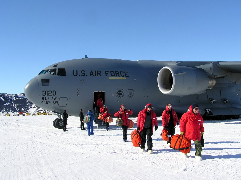
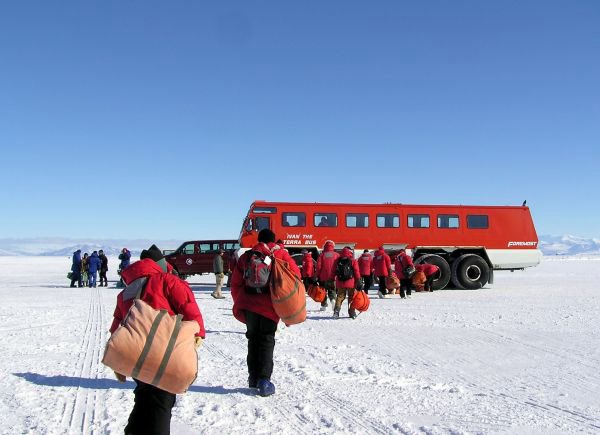
 We arrived on November 7th after a 5 hour journey on a C17 (military aircraft) from New Zealand. We landed on the sea ice in front of McMurdo and were greeted by "Ivan the Terra Bus," a slow-moving vehichle with enormous tires designed to travel on ice and snow. We're at McMurdo until November 15th sorting, packing, and weighing gear and equipment to get ready for the 2 1/2 month field season. It's been a hectic week. Everything is ready to go. Tomorrow we're taking all of our stuff to the helicopter pad and, if the weather is good, we'll be seeing penguins in two days.
Ross Island From Space
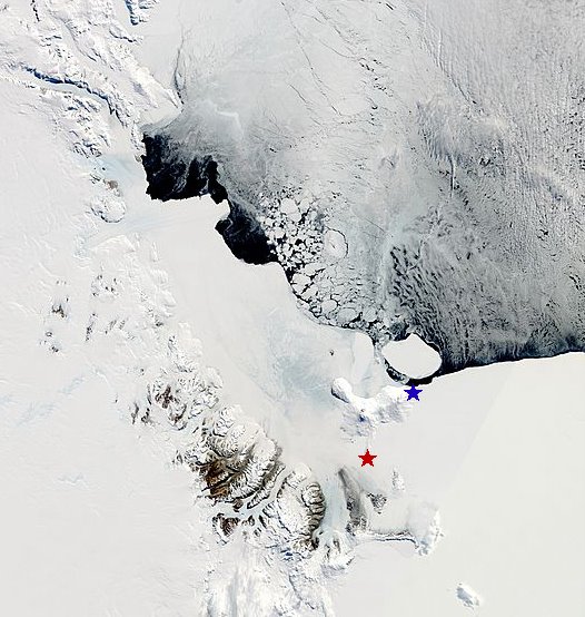
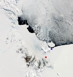 This is a recent image of Ross Island and vicinity taken from the MODIS Terra satellite. McMurdo station is the red star. It's on the SW tip of the island. Cape Crozier (one of our field sites and the location of the largest Adelie Penguin colony in the southern Ross Sea) is the blue star and is on the eastern tip of the island. The distance between the two stars is about 80 km. Surrounding Ross Island are sea ice to the E-NE, the Ross Ice Shelf to the E-SE, the Ross Sea to the north (filled with pack ice), and the darker brown Transantarctic Mountains to the SW, marking the coast of the continent proper. Black is open water, areas that are kept clear of sea ice by the persistent winds from the Antarctic ice cap.Directly in front of Cape Crozier is iceberg B15-J, a remnant of what was once the larger B15. It's been rotating in place and occasionally smashing into the coastline in front of the colony since 2002, making life harder for penguins that are trying to access the colony and forage during the breeding seaosn.
First glimpse of Antarctica
We have arrived!
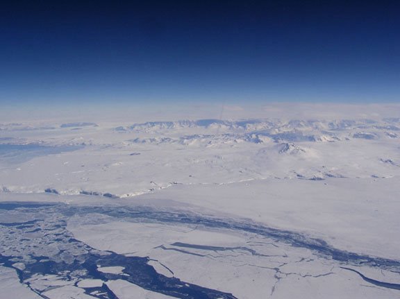
 This is our very first view of the continent as seen from the C17, a large military cargo plane used by the US Atarctic Program to transport cargo and passengers between New Zealand and Antarctica. I was looking out one of a few tiny scratched windows in the front of the aircraft when one of the "flight attendants," an Air Force man in his mid-twenties, invited me up into the cockpit for a better view. The Victoria Land coast lay beneath us in a vast expanse of snow and ice-capped peaks, wind-streaked sea ice, and an immense blue, clean sky. It was exhilarating. I watched in awe as we flew past Terra Nova Bay, Inexpressible Island, and the Drygalsky Ice Tongue, the jagged, floating tongue of a glacier that is born high in the Transantarctic Mountains and dives directly into the Ross Sea. We landed directly on the frozen sea.

